Update - 7th Nov 2023
Ancient Wood Inventory – an update on the update!
We have now started on the final phase of the Ancient Woodland Inventories for Bedfordshire, Cambridgeshire and Northamptonshire. Over the spring and summer nearly 500 woods across the three counties were surveyed by volunteers and staff. The results are being used to help assess woodland status, in combination with further historical research.
The Inventories are almost in their final form but there still a number of woods which require further confirmatory surveys or historical evidence. To complete this work The Woodland Trust and Natural England have agreed to fund a project extension through to next June. In addition, we will also be updating the Ancient Woodland Inventory for Leicestershire and Rutland as Leicestershire and Rutland Wildlife Trust did not have the resources to take this on. Katharine Flach will be carrying on with Cambridgeshire and finalising the Bedfordshire and Northamptonshire Inventories whilst Andy Lear will be working on Leicestershire and Rutland.
The updates for the three counties have found a large number of smaller woods – many between 0.25 and 2 ha in size – which were omitted from the original inventory. It has also allowed current ancient woodland boundaries to be refined using maps and information not available to the compilers of the original inventory.
In the case of Northamptonshire this has resulted in adding at least 350 ha of ancient woodland with the possibility that this might increase to 800 ha once all potential sites have been reviewed.
The case for Bedfordshire is different. Although many small woodlands will be added to the inventory few existing larger woodlands have been removed because further information has revealed they are secondary. A number of the latter were on the Greensand ridge where former heathland was planted with trees sometime in the 17th and 18th centuries – something the original compilers of the inventory were unaware of. A smaller area of woodland has been lost to development – including the conversion of a large part of Charle Wood into a golf course around the year 2000. This has reduced the amount of ancient woodland by 147 ha, but if all the potential new woodland is added there could be a small 41 ha increase in total area. Realistically however, the extent of Bedfordshire ancient woodland is likely to remain about the same.
For Cambridgeshire the total amount also looks to increase slightly. It currently stands at a net increase of just over 100ha of Ancient Woodland and a possible further increase of up to 450ha of sites which require further investigation. Some of the larger changes are actually inventory corrections - areas which were previously removed from the inventory due to woodland clearance but were replanted or allowed to regrow, or areas which were included but historical records now show evidence of use for agriculture within the past 400 years. However, the update has mostly brought about small alterations to known ancient woodland boundaries using old map boundaries and LiDAR (Light Detection and Ranging) to map according to external banks and ditches.
Thank you for getting involved in the surveys this year. We were able to gather information from across the three counties and from a far higher number of sites than we could possibly have visited ourselves! The survey responses and photographs which you submitted enabled us to age a large number of woodlands which have limited documentary evidence and add the categories of ASNW (Ancient Semi-Natural Woodland) and PAWS (Plantation on Woodland Site).
We hope that you enjoyed this year’s surveys and if you would like to take part again next year, we will be pleased to have help to survey specific woods throughout Bedfordshire, Cambridgeshire and Northamptonshire. Since this will be the final round of surveys for the project across BCN we will be concentrating the surveys in early spring on woodlands which still have unclear evidence. We will therefore produce a new range of materials and send information about these early in the New Year to everyone who was involved last year. Do let us know if you are not able to take part again next spring and we would be happy to remove you from the volunteer list.
Katharine Flach, Andy Lear
Update - 26th May 2023
Can a plantation be classified as ancient woodland?
Can a plantation be ancient woodland? This is a question which several people have brought up when surveying sites for the ancient woodland inventory update project. This short article aims to address this and explain why the answer can be yes.
You might have gone to look at a wood and been confronted by lines of trees in straight rows, young saplings in plastic tubes, or at its most extreme a dark wall of conifers. Your first thought might be to dismiss the site as not ancient and categorise it as a secondary plantation – a wholly manmade woodland. However, it is always worth a further look - as the photo of Bushshrubs Wood near Apethorpe in Northamptonshire shows.

Photo: Rupert Paul
Beneath the planted conifers can be seen bluebells and dog’s mercury – two ancient woodland indicator species. These are widespread through the wood. In fact, at least 11 indicator species have been recorded for this wood including wood anemone – a long lived plant with very limited powers of dispersal and almost entirely confined to ancient woodland. Looking around other indications that this is not a new woodland can be seen including surviving old oaks, and a possible boundary bank topped with old coppice stools. It would there appear that this is an ancient woodland site on which trees have been planted. This is backed up by the historical evidence. There are maps showing Bushrubs Wood going back to the start of the 17th century when it was part of the Cliffe Bailiwick of the Rockingham Forest, and it is mentioned in documents back to the 13th century.
Bushrubs is therefore classified as a Plantation on an Ancient Woodland Site (PAWS)
Bushrubs Wood boundary bank and old coppice stool
Bushrubs Wood, old oak tree. Photo: Rupert Paul
So, if you come across a plantation what should you look out for? Firstly, any remaining ancient woodland indicator plants such as bluebell, wood anemone, woodruff and ransoms. These may only be confined to the margins of the site, to open glades or along the edge of paths and rides. This applies particularly to conifer plantations – as they can shade out any ground flora and suppress growth with their fallen needles. Next, look out for surviving native veteran trees such as oak, ash and field maple – these may be holding on where the planted crop has failed or was incomplete. Again, woodland edges are a good place to find these as introduced trees aren’t always planted right up to the boundaries. Evidence of old coppice stools – particularly large multi-stemmed trees and shrubs such as hazel - may be survivors from former traditional management. Finally, look out for archaeological features such as large boundary banks and ditches. All these features can support the conclusion that the wood is a PAWS.
However, some former ancient woodlands have been so badly damaged by planting that they can no longer be classified as such. Mostly this will be because preparatory work before planting such as grubbing out the original trees, breaking up the soil with machinery to form planting ridges, and widespread use of herbicide to suppress plant growth has destroyed all the ancient woodland features.
In lowland Britain it is likely that all ancient woodlands have experienced planting at some point in their existence – if only to a limited degree. Even in medieval woods acorns were scattered to increase the number of oak trees. But where the character is still mainly semi-natural woodland with at least some native trees present and where the ground flora contains widespread woodland plants, it will still be classified as Ancient Semi-Natural Woodland (ASNW). An example of such a site is Lady Wood in Melchbourne, Bedfordshire (see photos), which has been planted with poplars but retains many mature oaks around the boundary and contains old ash, hazel and field maple coppice stools and widespread ancient woodland indicator plants in the ground flora. It very much retains its ancient woodland character despite the planted poplars as the second photo shows.
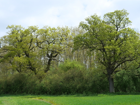
Lady Wood, Melchbourne, Bedfordshire. Old oaks with planted poplars in the background.
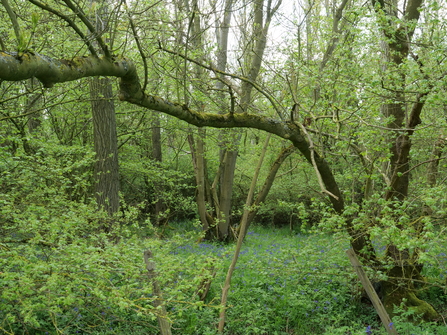
Lady Wood, Melchbourne, Bedfordshire. Old ash and field maple coppice stools, bluebells.
In conclusion, a wood can be planted and still be ancient. The most important consideration is that despite the introduced trees, the soil remains relatively undisturbed and that some ancient woodland features are retained.
Update 21st April 2023 - survey example
North Spinney and North Spinney borders – a relict fragment of ancient woodland
Fineshade Woods in Northamptonshire’s Rockingham Forest is a complex site containing a mix of ancient woodland and secondary plantations. Much of the AW is now Forestry Commission plantation and classified as PAWS (Plantation on an Ancient Woodland Site), although some semi-natural woodland (ASNW) still remains such as Far Markrams Wood in the northwest corner. The largest part of Fineshade Woods is a remnant of the Westhay, which lay in the Cliffe Bailiwick of the Rockingham Forest, a Royal Forest reserved for hunting. The northern part of Fineshade nearest Collyweston Great Wood is call North Spinney and The Assarts. An assart is an area of forest cleared for agriculture. However, the area is now entirely covered in trees. Much of this planting has occurred in the past 50 years. Looking at older maps it can be seen that before the 1960s much of the area of The Assarts was pasture, with Assart Farm at its north end. The farm has now gone but a description of its last days can be found here: Memories of Fineshade Wood. This might seem an unlikely place to find an unrecorded ancient woodland.

Fineshade Woods showing extent of currently designated ancient woodland
Examination of older maps including the First series 25 inch to one mile map (c1870) and the First Series 1 inch to the mile map of 1824 both show strips of woodland surrounding Assart Farm and continuing further south. However, the 1779 Eyre and Jeffreys County map doesn’t show woodland in this area and the maps in Rockingham Forest – an atlas of the medieval and early modern landscape G Foard, C Hall and T Partida (2009) appear to suggest that apart from North Spinney itself, this was cultivated land. However for a discussion of errors in the historical mapping of this part of Fineshade see the report by Sanderson (2014) Main Report.pdf (fineshade.org.uk).
Conceivably these could be remnants of ancient woodland which were left around the edge of the assarted area, as field boundaries were not mapped as woodland on early maps. Further research and a site visit were therefore called for to investigate this further. (On a similar note, Little Wood also appears to be a fragment of Westhay and therefore also possibly ancient.)
The earliest record of assarting of woodland in this area is in 1246 when 35 ½ acres were cleared (Foard et al pp210-212). A further assart was made in 1361 in an area called Duddington Short. The boundary of The Short runs along the south side of the strip of woodland running southwest from Assart Farm. Clearly therefore much of this area was cleared of woodland over 600 years ago, but did they leave a strip of woodland around the cleared area? – Similar shaws or woodland strips can be seen in the Weald in southeast England, and these are remnants of larger woods surrounding cleared fields. Perhaps this could be resolved by a site visit?
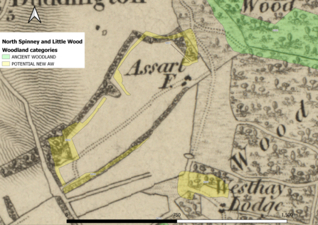
North Spinney, Assart Farm and Little Wood in 1824
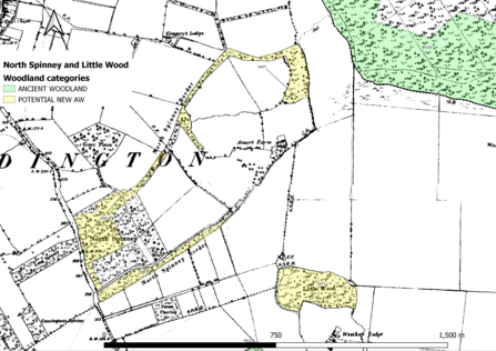
North Spinney, Assart Farm and Little Wood in about 1880. Yellow - Potential AW; green – AW
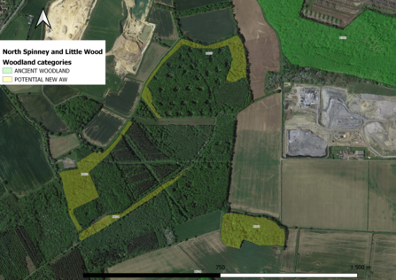
North Spinney and The Assarts: areas of potential ancient woodland overlaid on the current aerial photograph
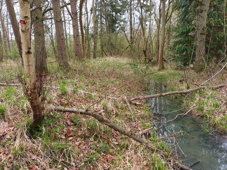
On 17th April a visit to North Spinney and The Assarts was made by Andy Lear and Barrie Galpin and our findings are summarised here. The strip of woodland curving around the north of The Assarts (N607) appeared to have been planted at the same time as the adjacent former pasture land with oak and ash being the most abundant canopy trees, with scattered conifers. However much of the potential ancient woodland area contained dog’s mercury and ten other ancient woodland indicator species scattered throughout. These species were mainly confined to the old woodland and did not spread far into the former pasture. The ancient woodland area was found to be delineated by boundary ditches – these appeared to be not medieval but more recent in origin. However, they did define the area containing ancient woodland indicators species. Along the outer edge field maple was more common, some of which appeared to have been coppiced in the past. Within the area to the north of Assart Farm the wood contains a series of linked artificial ponds which probably formed part of the water supply to the farm.
Moving southwest from the site of Assart Farm there is a ride which marks the north edge of the former linear woodland – North Spinney Border (N604). Along with the surrounding woodland the Spinney has been planted with a mix of species including oak, ash and wild cherry and at first glance looks very much like the surrounding plantation. However, in what was once North Spinney border, 9 ancient woodland indicators were recorded including bluebells and wood anemones. More exciting still, the southern boundary was marked by a broad but shallow bank with ditches on each side which is likely of medieval origin. This seems to mark the boundary of Doddington Short (part of the Royal Forest) and Doddington Assart (outside of the Forest). Here again ancient woodland plants didn’t spread much beyond what was once the Spinney.
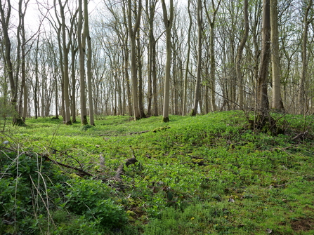
Finally, we moved on to North Spinney itself. The approach is along a sunken track, part of the ancient route from Kings Cliffe to Duddington. This is lined with a number of ancient woodland plants including sanicle. North Spinney is carpeted with wood anemones and bluebells. The main tree species was ash, with oak, both silver and downy birch, beech and a couple of specimens of hornbeam. Crab apple was found in the shrub layer. This looked very much like ancient woodland.
North Spinney Border, bank and ditch
North Spinney – a carpet of wood anemones as far as the eye can see
North Spinney wood - anemones and bluebells, Gwen Hitchcock April 2017
Overall the conclusion of the visit was that North Spinney and the borders around The Assarts are indeed ancient woodland which has survived as a shaw around an area cleared many hundreds of years ago and which has persisted and is now part of a larger secondary plantation. The intimate mixing of new and old woodland means that there is an opportunity for ancient woodland plants to spread throughout the area, something not possible where ancient woodland is isolated amongst agricultural land.
On a final note, if you examine the aerial photograph of North Spinney you will see a quarry to the west and a former quarry to the east (now a radioactive waste dump). The latter is now being extended right up to the edge of The Assarts and into the gap between Fineshade and Collyweston Great Wood creating a physical barrier to woodland species moving between the two woods. An example of how the principles (‘Bigger, Better, More Joined Up’) set out in the Lawton Report ‘Making Space for Nature’ (2010) the-lawton-review-factsheet.pdf (woodlandtrust.org.uk) are often ignored where national infrastructure projects are concerned.
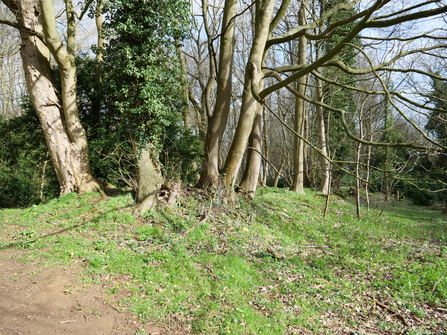
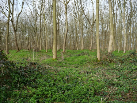
Update 4th April 2023 - survey example
Wothorpe Grove – a potential new ancient woodland for investigation
Wothorpe Grove, a 15ha woodland, lies in the Parish of Easton-on-the Hill in the North-East corner of Northamptonshire. There is a long recorded history summarised in Rockingham Forest – An Atlas of the medieval and early modern landscape (G. Foard, D. Hall and T Partida, Northamptonshire Record Society, 2009, pp213-214). Recorded as a woodland named Graves in 1261, referred to as le graves de Eston in a 13th century charter and in a 1253 agreement between Thomas, abbot of Croyland, and Sir Richard de Lindon about enclosing Graves in Easton on the Hill as part of a manorial park. In 1352 the park contained 30 acres (12ha) of woodland including one called Cranes thought to be a misreading of Graves.
Wothorpe Grove is shown as woodland on the 1824 OS 1” and other 19th century maps and is woodland today as seen on current aerial photographs:
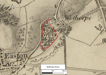
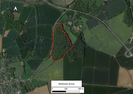
This therefore looks like a good candidate for adding to the Ancient Woodland Inventory. However, on a 6” OS map produced in the 1920s the wood is shown as rough grassland with a tree fringe:

Clearly the site did not have tree cover at some point in the early 20th century – but was this because it had been recently clear felled when the area was surveyed or had something else happened?
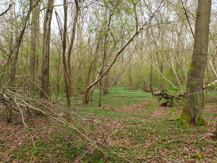
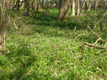
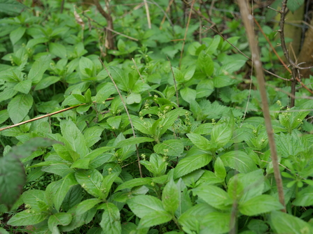
This is where a site visit and woodland survey has proved particularly useful. When Wothorpe Grove was visited at the end of March the following was noted (see the images below):
- A large bank runs along part of the length of the southeast boundary, shown here topped with a large multi-stemmed sycamore
- The trees were mainly even aged ash, with sycamore and rare beech. However, there was virtually no shrub layer
- Looking at the ground flora, the most common ancient woodland indicator was Dog’s Mercury (Mercurialis perennis) which grew over large areas of the wood
- Other ancient woodland plants were uncommon with a patch of Bluebells in the south part of the wood. However, the floor of the wood consisted of an extensive area of pits and mounds – a sign the this was once a ‘hills and holes’ quarry
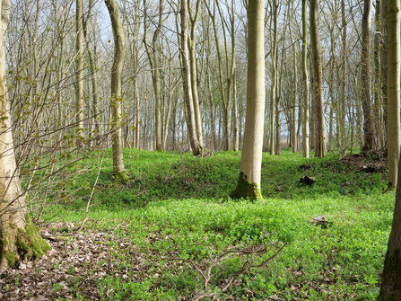
From this it can be concluded that, although a woodland with a long history, the quarrying in the early part of the 20th century mean that the soils have been disturbed and continuity of tree cover has been lost. Wothorpe Grove therefore cannot be considered an Ancient Woodland site. It is a secondary woodland, where the former quarry has been recolonised by ash and sycamore following cessation of quarrying. As a result, the trees are even aged and the structure of the wood is simplified, lacking a shrub layer. Dog’ Mercury has been able to re-colonise the wood probably because it is able to regenerate from root fragments which probably survived the ‘hills and holes’ quarrying - something many other woodland plants are unable to do.
This shows how a site visit and woodland survey can help to clarify mapping evidence and inform the decision making process for determining if a woodland can be considered ancient.
Links to the county ancient woodland inventory survey pages: